What has your roof been through?
Type your address to see your roof storm history by address: every hail, thunderstorm wind and tornado record NOAA holds within 10 miles of your home since the roof went on. It takes about a minute and it is free.
- Official NOAA records
- Alabama license #30154
- 6,000+ roofs since 1991
- Hail
- Wind
- Tornado
Storm records near your home
Reports by year
Every record within 10 miles
| Date | Type | Size or speed | Distance | Reported at |
|---|
County-wide records
High wind, tropical storm and hurricane records are logged for the whole county, not a single point.
| Date | Type | Speed | County |
|---|
These records show what was reported near your home. They do not show what happened on your roof. The only way to know is to look.
How to check hail history by address
The report answers one question a homeowner cannot easily answer alone: which storms were recorded close to this house while this roof was on it.
Type your address
We match it with the U.S. Census Bureau's address finder to get the exact spot on the map. No account and no email are needed to see the result.
Pick the roof's year
Choose the year the roof was installed. If you are not sure, leave it on the last 15 years. Storms before the roof went on do not count against it.
Read your report
You get a count of hail, wind and tornado records within 10 miles, a map with your home in the middle and a chart of which years were busy.
If the numbers concern you, the next step is a free look at the roof itself. Our roof inspection in Dothan comes with dated photos of every slope, and you can read the signs of roof storm damage to check from the ground first.
Has my roof had hail damage? What the sizes mean
The National Weather Service calls a thunderstorm severe when hail reaches 1 inch across, about the size of a quarter. Your report lists the largest stone reported at each location, in inches.
Under 1 inch (pea to penny). Common in spring storms. On a sound shingle roof it rarely leaves lasting marks, though it can knock granules off an old one.
1 to 1.5 inches (quarter to ping-pong ball). The severe mark. This is the size worth an inspection, because bruised shingles can look fine from the yard.
1.75 inches and up (golf ball or larger). Stones this size can crack shingles, dent metal panels and vents, and break skylights. Have the roof checked soon.
Wind damage history: what the speeds mean
Thunderstorm wind is severe at 58 miles per hour. Your report shows the measured or estimated gust for each wind record, converted to miles per hour.
Under 58 mph. Strong enough to drop limbs. A roof in good shape should hold; loose or aging shingles may lift.
58 to 74 mph. Severe. Shingles can crease or tear off along edges and ridges, and flashing can pull loose.
75 mph and up. Hurricane-force gusts. Expect missing shingles and exposed decking somewhere in the neighborhood. If water is coming in, call for an emergency roof repair.
Storm on your report and a roof you have not looked at since?
A storm damage report for my house: what a record does and does not prove
A record on your report means a trained spotter, an emergency manager, a weather station or a member of the public reported hail, damaging wind or a tornado at a place near your home, and the National Weather Service confirmed and logged it.
That is useful. It tells you which dates to think back to, and it gives you a reason to look at the roof before a small problem becomes a ceiling stain.
It is not proof of damage. Hail falls in streaks. One street can take golf-ball stones while the next gets rain. A roof two miles from a report may be untouched, and a roof with no report nearby may still have been hit, because not every storm gets reported.
That is why the report ends with an inspection and not a verdict. When we inspect, we photograph each slope with the date on the photo and give you a written scope of what we found. If you decide to file a claim, you file it with your insurer; those photos and that scope are yours to send. Our guide on how to file a roof insurance claim in Alabama walks through the steps.
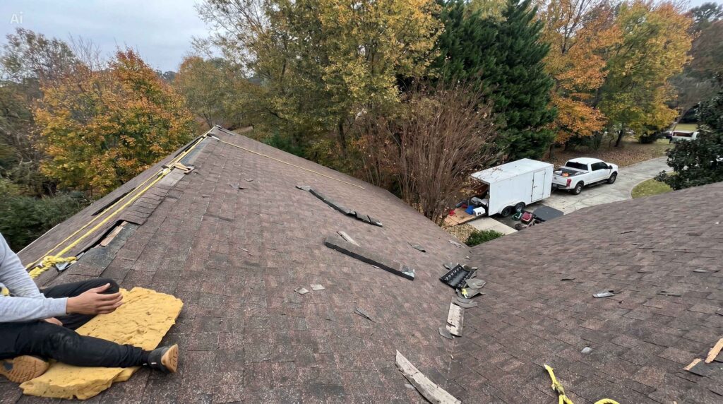
What we find on roofs after Wiregrass storms
Three photos from our own jobs. Each started with a homeowner who was not sure whether a storm had done anything.


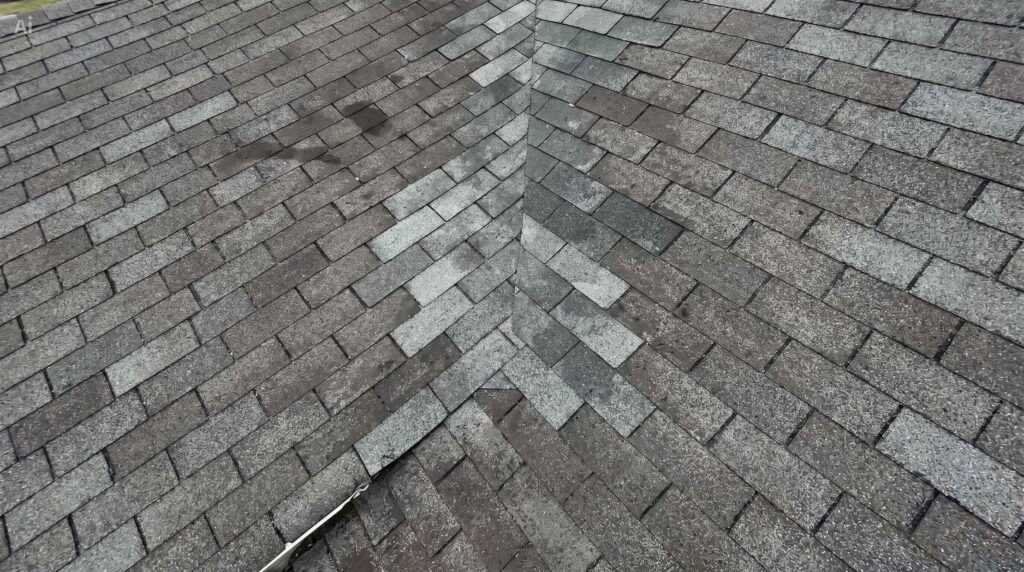
Most storm calls end in a repair, not a new roof. See how we handle storm damage roof repair in Dothan, and what a roof repair involves. Our work carries a 5-year workmanship warranty.
Where the storm records come from
Every record comes from the Storm Events Database, kept by NOAA's National Centers for Environmental Information. It is the official United States record of severe weather reports, and it is in the public domain. You can search it yourself at ncdc.noaa.gov/stormevents.
We copy the dates, hail sizes and wind speeds exactly as NOAA publishes them. The only math we do is measure the distance from each report to your address and convert wind from knots to miles per hour.
The limits you should know
- Near, not on. A record marks where a report was made, not your rooftop.
- Recent storms lag. NOAA publishes each month a few months after it ends, so last month's storm may not be listed yet.
- Not every storm is reported. Hail over an empty field at night may never be logged.
- County-wide events have no map point. Hurricanes, tropical storms and high wind are recorded for the whole county, such as Hurricane Michael in October 2018.
For the longer view, read our Houston County tornado history.
Wind and hail history for Dothan, AL and the Wiregrass
The report works for any home within 50 miles of Dothan. That covers Houston, Dale, Geneva, Henry and Coffee counties, plus nearby parts of southwest Georgia and the Florida Panhandle. We roof in these towns:
- Dothan
- Enterprise
- Ozark
- Headland
- Daleville
- Abbeville
- Geneva
- Hartford
- Slocomb
- Samson
- Malvern
- All Wiregrass areas
MAC Construction has roofed here since 1991 under Alabama general contractor license #30154. You can confirm the license with the Alabama Home Builders Licensure Board.
Questions about the roof storm history report
How do I check the roof storm history for my address?
Type your street address, city and state into the box at the top of this page and pick the year your roof was installed. In about a minute you see how many hail, wind and tornado records NOAA holds within 10 miles of your home since that year.
Is the storm report free?
Yes. The count of storms, the map and the year-by-year chart are free with no sign-up. The dated list with hail sizes and wind speeds is also free; we ask for your name and phone number so we can offer a free roof inspection.
Does a storm record near my home mean my roof is damaged?
No. A record shows that hail, wind or a tornado was reported near your home on that date. It does not show what happened on your roof. Only an inspection on the roof can tell you that.
Where does the storm data come from?
From the Storm Events Database kept by NOAA's National Centers for Environmental Information. It is the official United States record of severe weather reports. We copy it without changing any dates, sizes or speeds.
Can I use this report for an insurance claim?
You can use it to decide whether to ask for an inspection and to know which storm dates to mention. You file the claim with your insurer yourself. MAC Construction can give you dated photos and a written scope of the damage we find.
Which areas does the report cover?
Homes within 50 miles of Dothan, Alabama. That includes Houston, Dale, Geneva, Henry and Coffee counties and nearby parts of southwest Georgia and the Florida Panhandle.
How far back do the storm records go?
This tool uses NOAA records from 1996 to the most recent month NOAA has published. NOAA usually publishes a month of records a few months after it ends, so a storm from the last few weeks may not be listed yet.
Want a roofer to look? The inspection is free and comes with dated photos.